Chuck78 Posted November 6, 2013 Report Share Posted November 6, 2013 (edited) I'm hoping to get two more long rides in the next two Sundays before cold weather sets in for good. I have a route mapped out that will have me in at about 7 hours riding time including the express route from Columbus to Nelsonville on 33 (just to keep the trip shorter in these limited daylight times with cold temperatures also a concern). We rode past Burr Oak 12/01/2012 on 78, and it was better than the long stretch we did on 555 that day in my opinion, scenic, faster, more fun sweepers and twisties vs technical/rough-surfaced and non-scenic 555. that was a must ride in my opinion all the way to 377 where we split off south to catch 555 N to 669. I figured on just taking 78 all the way to Woodsfield to catch 26 all the way to Marietta. Then I got the idea to take maybe a half hour extra according to google maps and catch 255 south to the river and then 7 to 260N to 26 to Marietta. From there I figured a nice wind-down on 550 to 33 would do it, unless I really wanted to hit 555 and some other backroads to make a long long day if I wasn't frozen from a 54 degree high temp day yet. Looking for advice on these routes, especially with consideration to road conditions and tricky areas to watch out for since there may be damp leaves on the roads - making downhill braking into turns and cornering in general a little bit on the dangerous side. Basically my big question is - should I just ride 26 all the way from Woodsfield to Marietta, or is the short jaunt on 255 down to the river and then the boring rt 7 to 260N going to be better than the part of 26 that I cut out? Although I said I didn't think 555 was all that, I'm not into riding this far just for gentle sweepers, I just like nicer pavement and turns than 555 gave me north of 377. looking for smooth nice twisties of any speed with good surface, fun sweepers and hills, and SCENERY - cliffs and forests are a huge plus. Edited November 6, 2013 by Chuck78 Quote Link to comment Share on other sites More sharing options...
Chuck78 Posted November 6, 2013 Author Report Share Posted November 6, 2013 I'm going to skip the first part of 78 in favor of a short blast on 685 that I drove on last winter that was fresh pavement and a really awesome twisty rollercoaster ride to 13N to 78E to at least McConnelsville. Also, I may end up riding solo on this if anyone cares to join. I'm especially interested in meeting other people who ride vintage bikes. I push my 1977 Suzuki GS750 pretty hard in turns for a vintage bike (rim/tire/brake/swingarm mods to help me with that), but I'm no knee dragger on a modern sport bike. My MAC 4-1 exhaust's muffler scrapes before I get to knee dragging low on my lightened up but still 500 lb vintage beast. really hoping to get out the next two sundays before I retire the bike for the winter and tear the engine down for a 920cc upgrade and total rebuild. Here's a custom map link I made and saved. I am having the hardest time figuring out how you all post maps on here. Maybe the forums don't like custom saved google maps I guess. http://goo.gl/maps/Q1imR http://goo.gl/maps/Q1imR Quote Link to comment Share on other sites More sharing options...
Chuck78 Posted November 7, 2013 Author Report Share Posted November 7, 2013 GOT IT! The map posting, that is. Something like this if I don't do 255-7-260: 311 mi, 7 hours 37 mins vs about 6 hours 48 minutes via google if I took 550 from Marietta to Nelsonville to 33 www.google.com/maps?saddr=I-70+E&daddr=E+Canal+St+to:OH-685+to:OH-685+to:Broad+St+to:7th+St+to:W+Court+St+to:OH-26+S%2FOH-800+S+to:OH-26+S%2FOH-260+S+to:Greene+St+to:OH-676+W%2FLancaster+St+to:OH-676+W%2FLancaster+St+to:OH-676+W+to:Coal+St+to:OH-555+N+to:OH-555+N+to:OH-555+N+to:OH-669+W+to:Mill+St+to:Refugee+St+to:Refugee+Rd+to:Kelton+Ave&hl=en&ll=39.682405,-82.037915&spn=1.665637,2.463684&sll=39.953857,-82.958279&sspn=0.006481,0.009624&geocode=FTikYQIdsh0O-w%3BFRz4WQIdUmcZ-w%3BFQwsWgIdbhYa-w%3BFYMpWgIdXlkb-w%3BFZzdWgIdtaIb-w%3BFbAOXQIdeOce-w%3BFUO7XgIdy0Qq-w%3BFcFCXgIdE0kq-w%3BFd-uWwIdneUo-w%3BFSNcWQIdZiQl-w%3BFYCWWQIdjJEk-w%3BFQUvWgIdgn8i-w%3BFUxeWgIda-kf-w%3BFQ2KWgIdcNUe-w%3BFSK5WwIdhEAd-w%3BFbQCXAIdvDAd-w%3BFUtJXgIdITMc-w%3BFU82XwIdeYka-w%3BFeWdYAIdvt4X-w%3BFTfTYAId4Z0U-w%3BFTT6YAId1uYQ-w%3BFbKmYQId8CUO-w&t=h&mra=ls&z=9 Quote Link to comment Share on other sites More sharing options...
Chuck78 Posted November 7, 2013 Author Report Share Posted November 7, 2013 331 mi, 8 hours 9 mins if I skip the first half of 26 to hit 255 to 7 to 260. A half hour more. Quote Link to comment Share on other sites More sharing options...
Chuck78 Posted November 7, 2013 Author Report Share Posted November 7, 2013 352 miles 8 hours 39 minutes if I do all of 26, and do a loop of 255 to 7 to 800 to 26. Might try for this if 800 is a lot more enjoyable/twisty/scenic than 260. This route may necessitate shaving off the extra time on 555 and just take 550 to 33 due to the temperatures dropping by late afternoon to 50 or below. I will be bundled up for sure. Quote Link to comment Share on other sites More sharing options...
motociclista Posted November 7, 2013 Report Share Posted November 7, 2013 352 miles 8 hours 39 minutes if I do all of 26, and do a loop of 255 to 7 to 800 to 26. Might try for this if 800 is a lot more enjoyable/twisty/scenic than 260. This route may necessitate shaving off the extra time on 555 and just take 550 to 33 due to the temperatures dropping by late afternoon to 50 or below. I will be bundled up for sure. I would probably go this route myself, though I shouldn't say for sure because it's been a while since I've been over on 26 and can't remember details enough to talk about the merits of staying on 26 vs. these detours. I do know 255 is a favorite of mine. One minor note: the bypass around Nelsonville is now open, so that should shave 10 minutes off the boring part of your travel time right there. You'll get on 78 without entering Nelsonville. Quote Link to comment Share on other sites More sharing options...
drc32-0 Posted November 7, 2013 Report Share Posted November 7, 2013 I would do the 255>7>260>26 option...although you'll miss what I consider the best part of 260...from 26 north to Marr. There is some new pavement on 26 from 537 to 260,but this section of 26 isn't anything special.As a matter of fact I would ALWAYS take the 537/260 option over this section of 26.This part of 537/260 is some really good riding. I was on all of these roads two Sundays ago...there is some fracking related work going on on the bottom 4-5 miles of 255,the road might be dirty and look out for big trucks,otherwise 255 is good.260 is one of my favorites and the fall colors were still good on it when I rode it...probably not now.But 800 is a good choice also...new pavement in the last two years from Fly(7) to 255.Probably less traffic on 260 though. Newly paved 676 will be a highlight. That area is just full of great roads...you can't hardly go wrong with whatever route you choose. Enjoy your ride. Quote Link to comment Share on other sites More sharing options...
whaler Posted November 7, 2013 Report Share Posted November 7, 2013 255 is not a good road. Its dirty, rough, and narrow. Rode last month and every turn was full of gravel. Take 800 to 7 to 260 to 26. Quote Link to comment Share on other sites More sharing options...
Mary#17 Posted November 7, 2013 Report Share Posted November 7, 2013 I don't care for 555. Never been a favorite of mine. 550 is more fun especially the section just outside of Athens. There's a section there that I would go back forth on all day if I could figure out a way to not get in trouble doing it. 685 is a blast but short. 691 from 33 south to 56 is all new pavement and very nice. 278 near lake hope has some really fast sweepers as does 56 near 691 and 374. 26 had a ton of construction and truck traffic when we went on it in mid October. 255 used to be a blast but I've heard from numerous sources that the road conditions are just plain dangerous. 78 east of Caldwell isn't really that interesting. I'd cut that part out and go up 260 from 26. Mary Quote Link to comment Share on other sites More sharing options...
Chuck78 Posted November 7, 2013 Author Report Share Posted November 7, 2013 all of this is very helpful information, thank you to everyone. I will probably cut out the latter part of 78 and head from Nelsonville on 78 and then south on 260 to 26 or 7, then loop some combination of 255, 800, 26, & 7 back to Marietta on 26. I will try to incorporate 537 into that somehow, as it looks and sounds awesome from the map and fresh pavement reports. After reading a lot on 255, I am still very curious to ride it. I assume from the river north on 255 to 800 is the best bet, more uphills I assume. From there, I could take 26 to Marietta to 550 then.if enough people tell me that 800 going to be much better than 255 right now, I might just skip 255, but I am still very curious after all of the reading I have done on it from other riders' route reviews.So... 26 NE of 260, just so-so? or are there some really great worthwhile parts? If I skip 260 south of 26, I could loop both 802.15.4 together and backtrack on 26, with minimal time on route 7 which I could care less about. Is it worth it to hit both of those roads and skip the southern part of 260? or is the southern part of 260 better than one or the other of 255 and 800? Quote Link to comment Share on other sites More sharing options...
Chuck78 Posted November 7, 2013 Author Report Share Posted November 7, 2013 Phone typo above, supposed to say "loop 800 & 255" Quote Link to comment Share on other sites More sharing options...
Mary#17 Posted November 7, 2013 Report Share Posted November 7, 2013 Oh! I have done 537 in the past and that is fun. Short but fun. I like 800. Newer pavement. More of a fast sweeper route than tight. Quote Link to comment Share on other sites More sharing options...
Chuck78 Posted November 7, 2013 Author Report Share Posted November 7, 2013 (edited) so it looks like I should take 676 out of Marietta instead of 550, and then turn on to 555 at the end and either take the short route north home555 to 669 (nice road newer pavement)to 204 or 70, or south to 550 to Athens. 550 doesn't look like all that much on a map but a nother rider that is a friend told me that it was pretty great. He sold his gs550 and bought a Yamaha 1100 v-star cruiser or something, so I didn't necessarily trust his judgement on twisty roads, but with Mary backing that up, it sounds like 550 near Athens is really worth it, especially considering that I wasn't very thrilled with 555 unless it gets better south of 377 towards the river.Standing on a roof fixing some restaraunt hvac equipment in 46° and some wind is making me second guess a ride sunday if temps arebelow 50°! Might use a vacation day soon instead whenever it gets closer to 60, or else wear my insulated carhart jumpsuit! 50° & sunny rides last fall seemed alright bundled up, hope the forecast stays warmer. Edited November 7, 2013 by Chuck78 Quote Link to comment Share on other sites More sharing options...
Mary#17 Posted November 7, 2013 Report Share Posted November 7, 2013 The fun part of 550 is between 555 and 377. West of that is ok but there's a stretch by 377 that is just wicked fun. Have a good trip. Quote Link to comment Share on other sites More sharing options...
Chuck78 Posted November 8, 2013 Author Report Share Posted November 8, 2013 (edited) WOW... I started really looking at the map and checking out other roads after reading a few mentioned on this forum. There are a TON of awesome roads in the triangle formed south of 78 and east of I-77 and bordering the Ohio River... I'm hoping for mid-50's and sunshine so I can get off to an 800AM start and ride all of these roads, which is going to be almost 9 hours riding time to and from Columbus. I need some sightseeing time, gas and food time, and need to be to Athens by 5. A very ambitiously long ride for the temps. Thanks to your help, here's the best route I could put together without going way over in riding time. This cuts out the eastern part of 78 to hit part of 260 south to 565/537, then a loop of 800S to 7E to 255N, and then back on 26 with a bypass back on 537Wto 260S back to 26. Also a detour off 550 on 676 for quite a ways. 376 miles, 8 hours 50 minutes from near I-70 and 33 in Columbus.6 hours 40 minutes on 249 miles of top notch twisty roads east of US-33! Only problem is a severe lack of gas stations when exploring the area - basicallly Caldwell, Lewisville, and Woodsfield on 78, and NOTHING forever south of there until all the way down to the river - Marietta, Hanibal @ routes 536 & 7, and Matamoras near routes 260 & 7. This is a good sign (very undevelopable area due to the topography aka better riding terrain) but also needs a lot of attention to mileage. Thats A LOT of primo riding terrain with very very few gas stops anywhere near the heart of it. Google Map search "Gasoline near Stafford, OH." Point Marker "M" on the map at 800/26 in Woodsfield is strictly a 4 mile jog off the route to get gasoline. Edited November 8, 2013 by Chuck78 Quote Link to comment Share on other sites More sharing options...
Chuck78 Posted November 8, 2013 Author Report Share Posted November 8, 2013 https://www.google.com/maps?saddr=Pleasantview+Ave%2FPleasentview&daddr=39.4663472,-82.188542+to:OH-685+to:OH-685+to:Broad+St+to:OH-78+E%2FWoodsfield+Rd+to:OH-145%2FHarriettsville+Rd+to:OH-565+E+to:OH-537+E+to:OH-800+S+to:OH-800+S%2FMorrison+Ln+to:OH-255+W%2FMuskingum+St+to:OH-255+W+to:S+Main+St+to:OH-260+S+to:OH-26+S+to:Greene+St+to:OH-676+W+to:OH-555+S+to:OH-550+W+to:OH-550+W+to:US-33&hl=en&ll=39.592461,-81.268616&spn=0.416952,0.589142&sll=39.667557,-81.151886&sspn=0.416499,0.589142&geocode=FX1AWgIdN1YZ-w%3BFWs1WgIdAucZ-ymJQSvDIwpIiDE6pJsYCZYaqA%3BFQwsWgIdbhYa-w%3BFYMpWgIdXlkb-w%3BFZzdWgIdtaIb-w%3BFcO6XgIdUBwm-w%3BFWXGXAIdFQ4n-w%3BFdyMXAIdFXco-w%3BFTbiXAId4lkp-w%3BFZBAXgIdu0wq-w%3BFfW4WwId6O8r-w%3BFQGdXAIdD2At-w%3BFSIAXgId2I8r-w%3BFWOzXgId_EAq-w%3BFfoEXAId2MMo-w%3BFS1xWwIdVJEo-w%3BFSNcWQIdZiQl-w%3BFdUQWgIdmB0h-w%3BFccTWgIdwYAf-w%3BFaqDWQId248f-w%3BFR6fWAIdACkb-w%3BFUQIWgId94gZ-w&t=p&mra=ls&via=1&z=11 Quote Link to comment Share on other sites More sharing options...
drc32-0 Posted November 8, 2013 Report Share Posted November 8, 2013 If you don't like that ride you might as well give up on SEO roads. You have some of the best sections of some of the best roads in SEO...many with very good to new pavement. Enjoy your ride and let us know what you think when you get back. Quote Link to comment Share on other sites More sharing options...
DeansZG Posted November 9, 2013 Report Share Posted November 9, 2013 Nice route!! Although, with that said, you might want to have a couple of "alternative, ie; shorter" routes in your mapping software / tankbag / whatever, that you can revert to if the weather or time starts to work against you, especially at this time of the year. We stayed at Burr Oak on a saturday this past September & started out east on Rt78 right after a late breakfast which was about 9:30. Running pretty much the route you mapped out in your 3rd message in this posting, up to Marietta, then turned on Rt550 & ran that all the way to Rt13 s. of Chauncey. With a quick stop at the market in town, we didn't return to the lodge until 6 pm. We stopped for a couple of pics & smoke breaks along the way, & mostly had the route to ourselves( I think we only had 5-6 cars to deal with the whole time while on 78), but our pace was brisk & it still took us longer than we had thought it would(in a good way though)... Quote Link to comment Share on other sites More sharing options...
Chuck78 Posted November 9, 2013 Author Report Share Posted November 9, 2013 Yeah I'm going to make a custom google map route saved to my google account so that I can view it offline on the trip on case I get lost or tired & need a quick way home. I've got the route mostly memorized from all the google map time geeking out about awesome roads, but its nice to have a paper copy & map on the phone. If you downgrade to google maps 6.2 up to 6.9 on android, you can still access your saved routes from your google account. Maps 7.__ sucks and lost that feature. Also if you increase your google maps cache to the max, then before the ride, zoom in to view the entire route close up, you will now have it all stored in your phone for offline viewing in remote areas of no cell service.Leaving 8am Sunday solo if anyone wants to join.highs in the low 50's. Quote Link to comment Share on other sites More sharing options...
Chuck78 Posted November 10, 2013 Author Report Share Posted November 10, 2013 Well I'm going to have a go at it tomorrow morning and try and start at 8am when it's 41 degrees. Not certain I will do the entire route plan or not, but I will be heading to Southeast Ohio for some portion of the day at least, and hope to hit 255 and 800 in there, but if time is not on my side, I may have to cut those out for this trip. Here's a saved custom google map I plotted out so that I can access these directions using Maps 6.9 or earlier (the android app). This shows 5.5 hours driving time, but the same route through the google driving directions link I posted shows closer to 7 hours. I marked a few strategic gas stop spots in any stretch that would go over 75 miles just in case. https://www.google.com/maps/ms?msid=207813457435995713568.0004eac6d9d62f3b3baa9&msa=0 I may try the GPS Essentials app with this route, although I have not figured out 100% how to use the .kml GPS file that you can download from that google map link. Last I tried a route, it showed only the placemark points and not the route. So on this map, I added a placemark at every point where you would turn. By now, I think I have this route pretty much memorized. Going to bundle up in a Dickies insulated work jumpsuit, leather jacket, scarf, and some winter gloves for the first hour, thinsulate leather riding gloves after that. My 54 degree sunset ride home today proved really chilly, but tomorrow, hopefully being bundled up will really help. Thanks for all the route tips everyone. Quote Link to comment Share on other sites More sharing options...
Pokey Posted November 10, 2013 Report Share Posted November 10, 2013 Tomorrow I am looking to bust down 33 to Nelsonville, take 78 to 800 then pick up 255 to 7. Take 7 up to 536 and then take 800 up to 70. Figure I will just bust ass home on 70, going 75/80 will make up some good time. Quote Link to comment Share on other sites More sharing options...
Chuck78 Posted November 10, 2013 Author Report Share Posted November 10, 2013 What time are you heading out? Just woke up at 7am to some serious 30-35 mph wind gusts, and was starting to doubt wether I should go for the long route or not. That route is similar, but I had read a lot of bad reports on 536 road conditions, so I skipped it. I need to adjust my clutch and throw on my saddlebags and fix some food, so it may be 830-9 before I head out with any decisions on the ride. Let me know if you want any company. Quote Link to comment Share on other sites More sharing options...
Chuck78 Posted November 11, 2013 Author Report Share Posted November 11, 2013 Wow that was some nice riding, I'll give a better recap later. 255&537 were awesome! Unfortunately got off to a late start & was approaching the good stretch of 550 @ 440pm @50-55mph when a deer bolted outta nowhere right in front of me! I kept it on 2 wheels, but it smashed my speedo headlight & turn signal to pieces, bashed my knee real hard between the deer's skull & my gas tank, so now I have a "knee dent" in my tank on one side. Literally. Knee is all swollen & antler or tooth of deer gouged thru all three layers & took a chunk of skin out. Wow am I ever lucky.I am always the one to tell my friends "watchbout for deer, ESPECIALLY starting 1 hour before sunset." I've seen many many deer on my bike, but they always look scared from the loud exhaust & aggressive camshaft sound, and usually run the other direction. Don't ever get too comfortable riding in deer country! Waiting for the AAA tow, I saw several locals driving well below the speed limit after dark, and I'm sure that's why. I almost rode it to athens to try & get a bulb, but the lens was gone, probably not a safe way to travel home at sunset on US33...Wow I am lucky. Be more careful than I was...please! Hope my knee is just swollen & bruised. Amazing that I didnt go down. Broke my #1 plug wire resistor cap & bent the top of the plug even. Deer fur stuck in the plug wire & headlight trim... Quote Link to comment Share on other sites More sharing options...
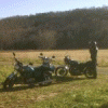
Chuck78 Posted November 11, 2013 Author Report Share Posted November 11, 2013 This is a shot right after the deer tried it's hand at bodywork using my knee as the tool to put cafe racer knee dents into my GS750... demolished my headlight bucket/lens/bulb, turn signal and bracket, speedometer, #1 spark plug and resistor cap end, stator cover gasket leaking oil now, and my knee swollen up like a grapefruit. It is amazing that I was able to stay on two wheels and didn't get more severely injured. Some force beyond me was looking out for me, trying to give me a "gentle" warning of the forces of nature and man-made machines... Quote Link to comment Share on other sites More sharing options...
Mary#17 Posted November 11, 2013 Report Share Posted November 11, 2013 That sucks. Glad you seem to be ok for the most part. Quote Link to comment Share on other sites More sharing options...


Recommended Posts
Join the conversation
You can post now and register later. If you have an account, sign in now to post with your account.